Convert a floor plan image to DXF.
A lot of buildings only exist on paper: an old blueprint in a binder, a landlord's scanned PDF, a photo of the fire-escape plan by the lift. When the next step needs a real CAD file — a DXF or DWG for a wireless site survey, a facilities system, or an architect — a picture isn't enough. Gridsnap turns the picture into the CAD file: import it as an underlay, set the scale against one known distance, trace the walls, and export a clean DXF — or DWG — at true size.
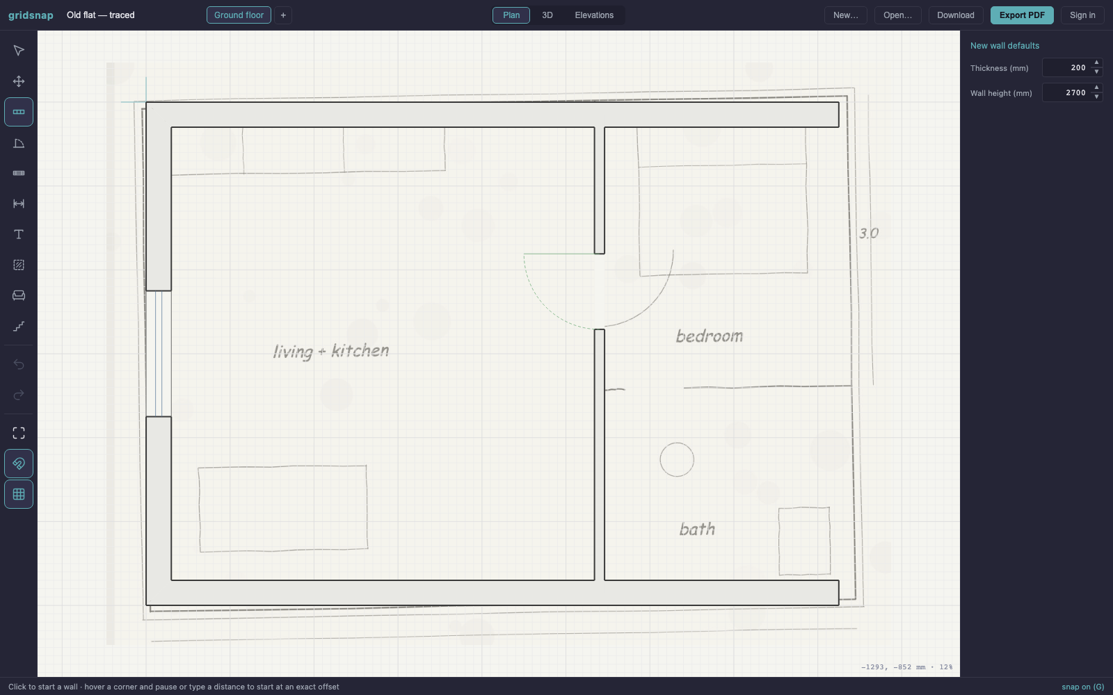
From blueprint to DXF in four steps
Drop in the image you have — a scan of a paper blueprint, a photo taken on site, a PNG, or a screenshot of a PDF page. It appears as a faded underlay beneath the drawing grid.
Click two points whose real distance you know — a printed dimension, a doorway, a wall you've measured — and type it. From then on the model is in true millimetres, which is exactly what the DXF will carry.
Draw over the underlay. The snap engine keeps walls straight and corners exact even when the scan is skewed or the paper was creased — you trace the building, not the pencil line. Doors and windows snap onto the walls.
One click in the Export dialog produces a clean vector DXF or DWG: millimetre-accurate model space, with walls, openings, text and dimensions on their own layers. Free, no watermark, no account.
Or send it over and we'll trace it
If the plan matters more than the half hour, we'll do the tracing. Send the blueprint in whatever state it's in — a phone photo, a scan, a PDF page — and you get back a millimetre-accurate DXF with walls, doors, windows and dimensions on their own layers, ready to drop into Ekahau, Hamina or a facilities system. €29 per floor, usually back within two working days — pick what you need below and the price follows.
Evaluating whether your survey tool will accept the output at all? Say so and the first one is free — we'd rather find out together that it works than take €29 to find out it doesn't.
Built for wireless surveys and facilities work
This workflow gets the most use from network and facilities engineers. Wi-Fi survey tools like Ekahau and Hamina will accept a plain image of a floor, but the survey is only as good as the map under it: a CAD file carries real wall geometry at true scale, so the prediction model works with actual walls instead of pixels. Platforms for indoor wayfinding and asset tracking often won't take an image at all — they require CAD.
The trace workflow covers both: ten to thirty minutes with the blueprint gets you a millimetre-accurate DXF — and where a platform insists on DWG, Gridsnap writes AutoCAD 2018 DWG directly, so there is no converter in the chain and nothing to install. As a bonus, the traced model isn't a one-off export — it stays editable in Gridsnap, so the next survey or refit starts from the model, not from paper again.
Why the DXF comes out clean
Gridsnap isn't a drawing app exporting a picture — it's a small CAD engine. Everything you trace is stored in integer millimetres, walls are solved into exact mitered geometry, and the CAD file is written from that same geometry: real model space at 1:1, in millimetres, with walls, openings, dimensions, areas, furniture and text on separate layers you can toggle in the receiving tool. Take it as an AutoCAD 2018 DWG, the same drawing as a 2018 DXF, or the legacy R12 ASCII DXF when a tool wants the oldest flavour there is. The same model also exports a true-vector PDF at printed scale, if paper is where it needs to go back to.
Common questions
Tracing a plan to edit it rather than convert it? See editing an existing floor plan — same workflow, aimed at renovations. New to plan drawings? The floor plan symbols guide explains what everything on the blueprint means.
Is the conversion automatic?
No — Gridsnap doesn't auto-vectorize the image. You trace the plan over the calibrated underlay, and the snap engine does the precision work: walls come out straight, corners exact, dimensions real. A typical floor takes on the order of 10–30 minutes, and the result is a clean CAD model rather than a best-guess auto-trace you'd spend the same time correcting.
What kind of DXF does Gridsnap export?
Two, and you pick in the Export dialog. The 2018 DXF (AC1032) carries the pages you ticked — plans and elevations in model space at real size in millimetres, a paper layout per sheet, native dimensions, and layers named by view. The R12 ASCII DXF is the legacy one: the current floor's plan alone, on layers for walls, openings, dimensions, areas and text — the oldest and most widely read flavour, for a tool that refuses anything newer. Both open in AutoCAD, LibreCAD, QCAD and anything else that reads DXF.
My tool requires DWG, not DXF. What do I do?
Export a DWG. Gridsnap writes AutoCAD 2018 DWG directly in the browser — the same drawing as the DXF, with model space in millimetres, a layout per sheet and native dimensions — so there is no converter step and nothing to install. It opens in AutoCAD — checked in AutoCAD Web and the Autodesk Viewer.
Does this work for Wi-Fi site surveys (Ekahau, Hamina)?
Yes — this workflow exists for exactly that job. Survey tools accept plain images, but a CAD file carries real wall geometry at true scale, which makes the survey model much more accurate. Trace the blueprint once, export the DXF — or the DWG, if that is what the tool takes — and import it into your survey tool.
I only have a PDF. Can I convert it?
Take a screenshot of the PDF page and import that as the underlay. A PDF floor plan is just a picture of a plan, so the screenshot loses nothing — and after calibration the traced model is at true scale regardless of the screenshot's resolution.
Is the DXF export free?
Yes, and so is the DWG. Importing an underlay, calibrating, tracing and exporting — DWG, DXF, vector PDF and PNG — are all free, with no watermarks and no account required.
Got a blueprint to convert?
Import it, calibrate, trace — and export a millimetre-accurate DXF or DWG. Free, no account needed.